Kshitij Goel Robotics Researcher

Decentralized Uncertainty-Aware Active Search with a Team of Aerial Robots

ISER · 2025

How do we leverage a team of aerial robots to search for an unknown number of objects of interest (OOI) in a communications-denied environment?

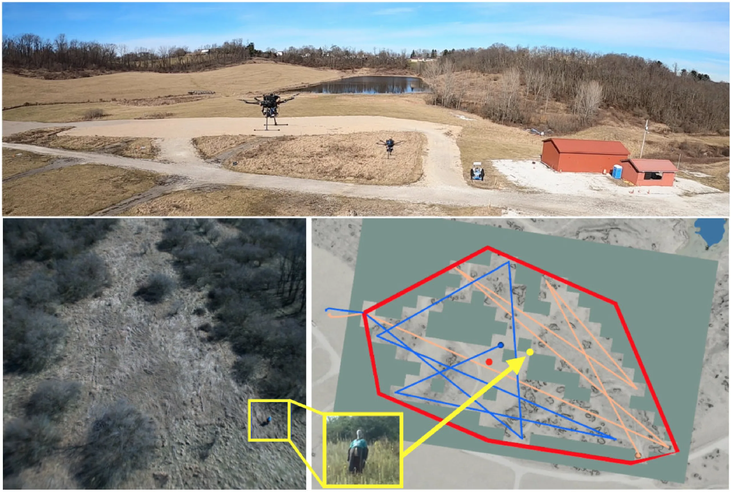
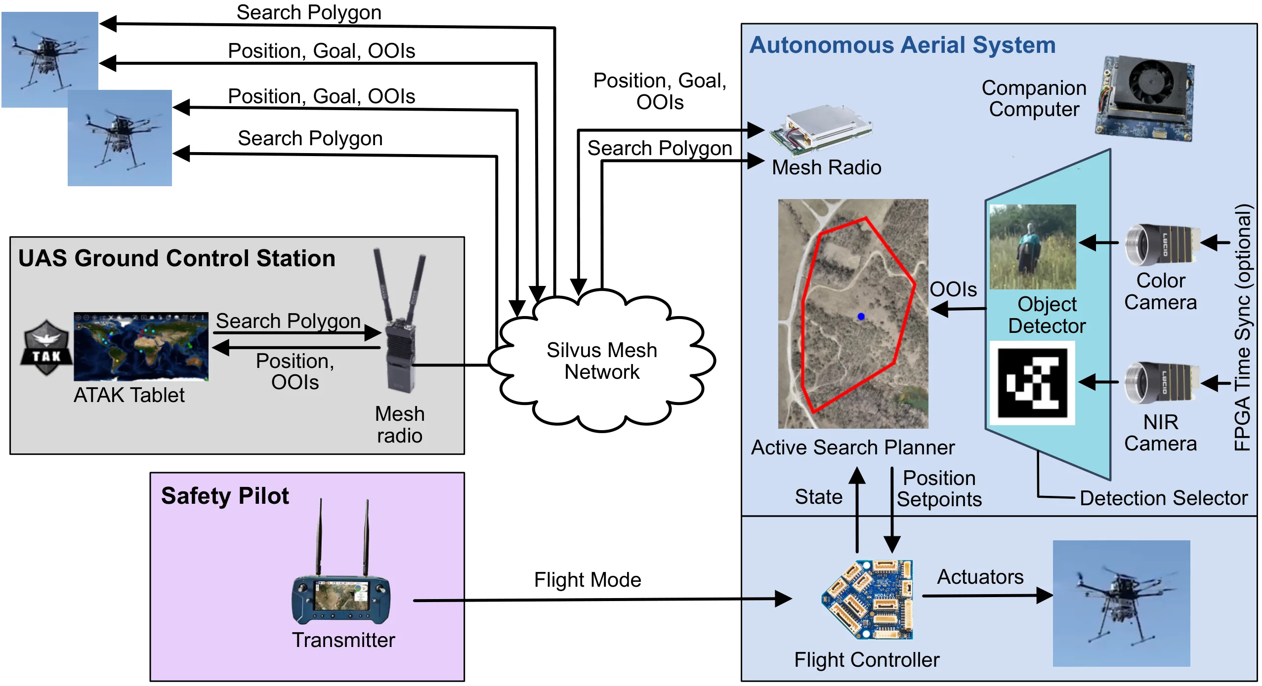
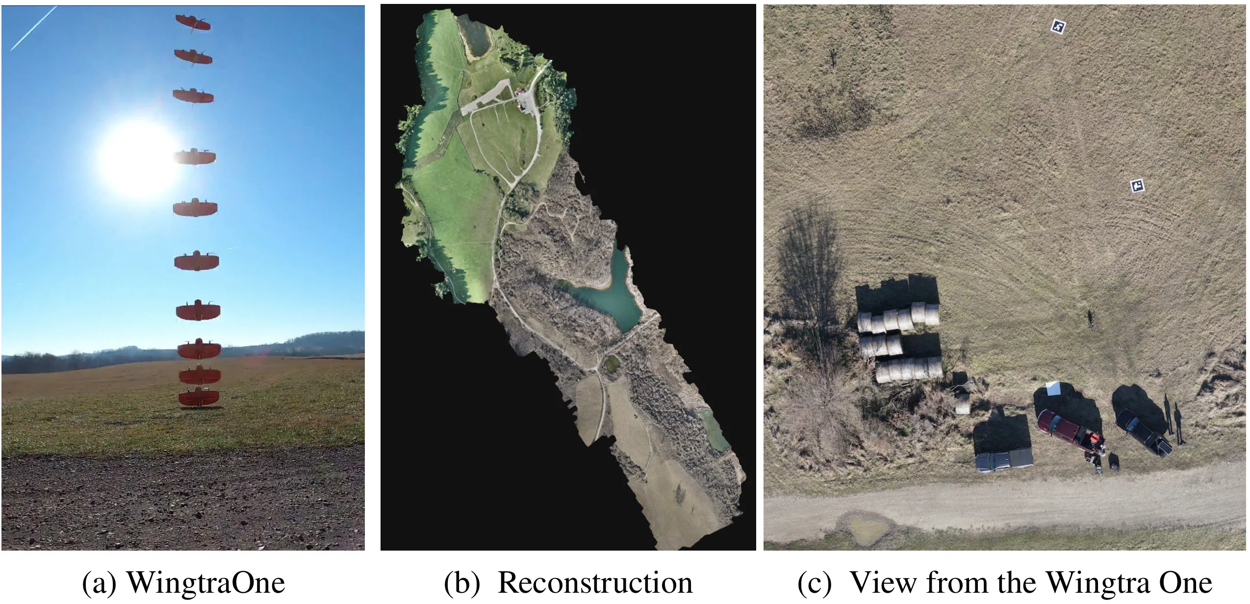
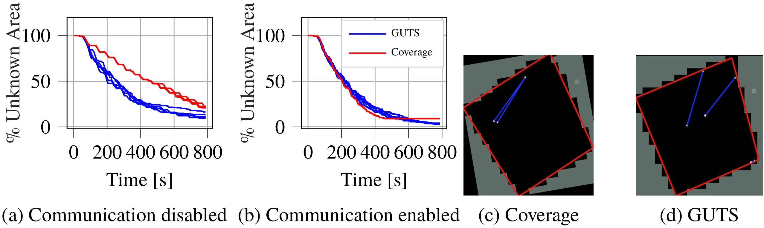
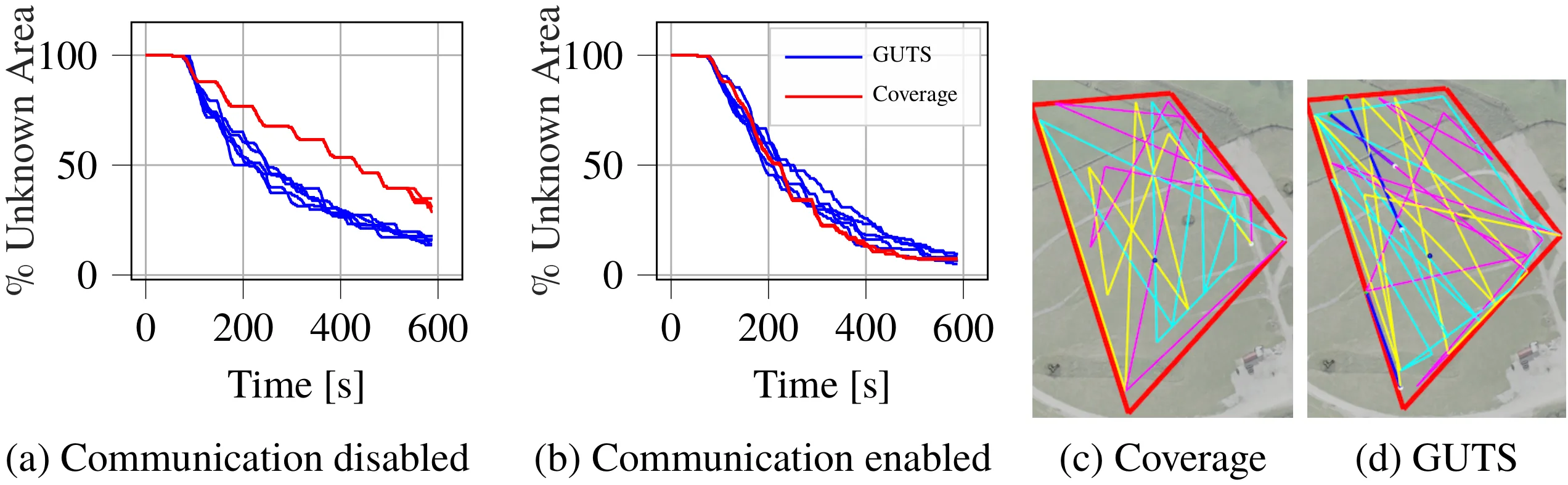
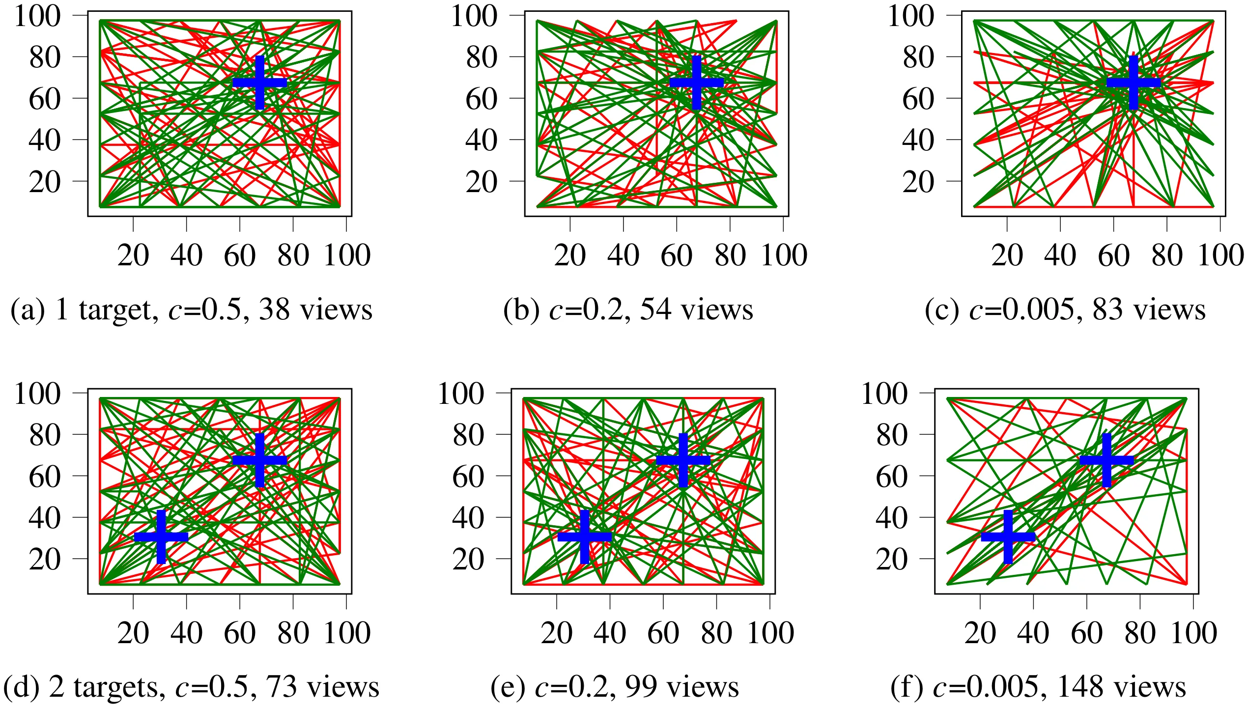
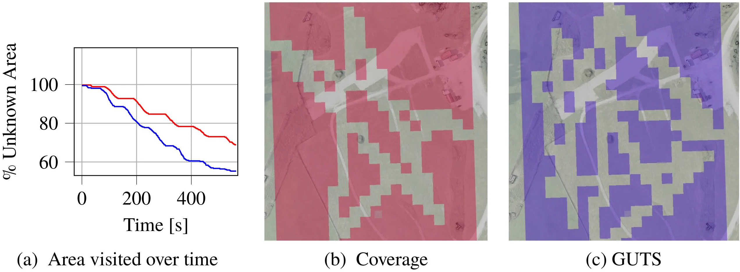
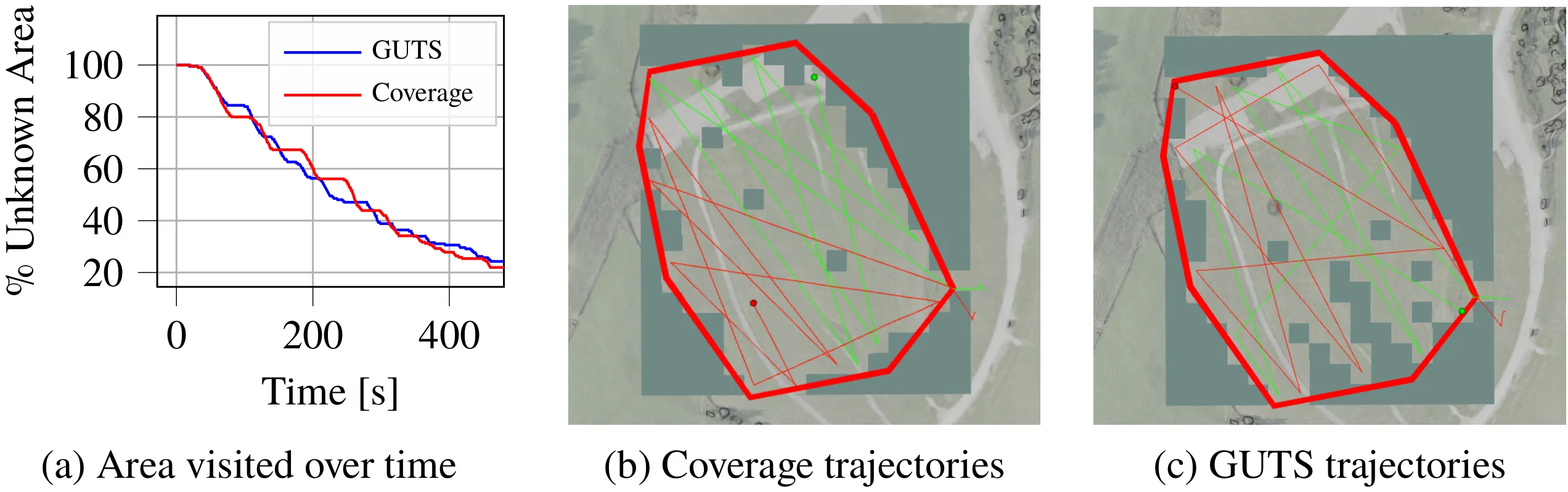
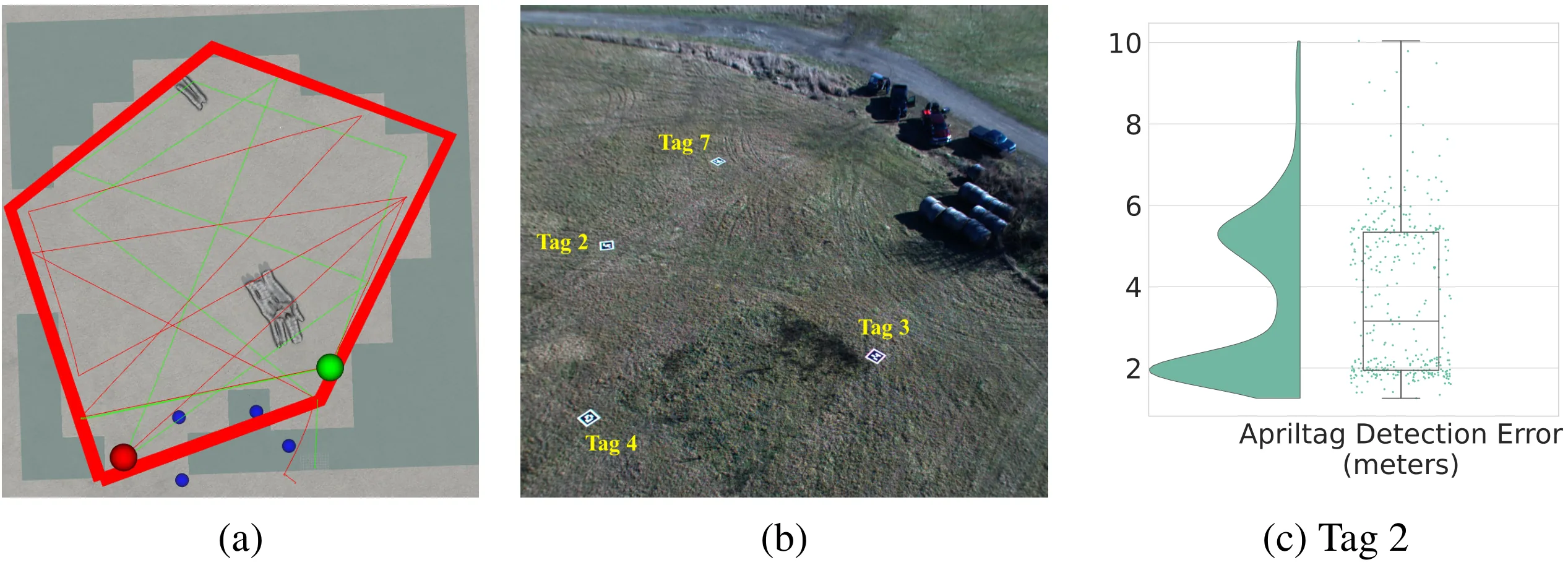
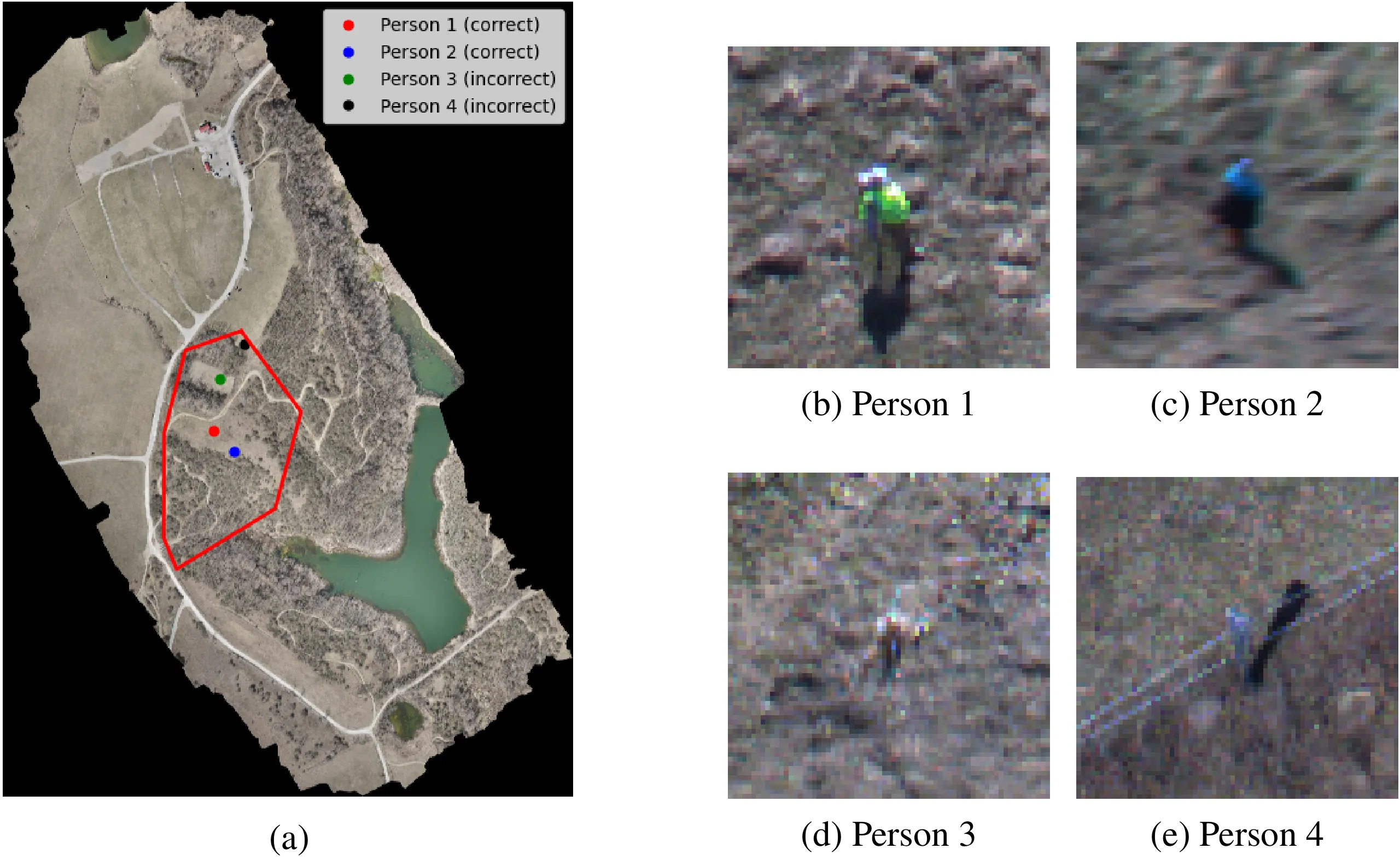
Rapid search and rescue is critical to maximizing survival rates following natural disasters. However, these efforts are challenged by the need to search large disaster zones, lack of reliability in the communications infrastructure, and a priori unknown numbers of objects of interest (OOIs), such as injured survivors. Aerial robots are increasingly being deployed for search and rescue due to their high mobility, but there remains a gap in deploying multi-robot autonomous aerial systems for methodical search of large environments. Prior works have relied on preprogrammed paths from human operators or are evaluated only in simulation. We bridge these gaps in the state of the art by developing and demonstrating a decentralized active search system, which biases its trajectories to take additional views of uncertain OOIs. The methodology leverages stochasticity for rapid coverage in communication denied scenarios. When communications are available, robots share poses, goals, and OOI information to accelerate the rate of search. Detections from multiple images and vehicles are fused to provide a mean and covariance for each OOI location. Extensive simulations and hardware experiments in Bloomingdale, OH, are conducted to validate the approach. The results demonstrate the active search approach outperforms greedy coverage-based planning in communication-denied scenarios while maintaining comparable performance in communication-enabled scenarios. The results also demonstrate the ability to detect and localize all a priori unknown OOIs with a mean error of approximately 3m at flight altitudes between 50m-60m.

Figures

Field Deployment
Field Deployment The decentralized, multi-agent team of aerial robots autonomously searches for and localizes objects of interest (OOIs) with approximately 3 m error at altitudes up to 60 m. (top) A team of three aerial systems conducts active search. (bottom-left) Onboard view of OOI (outlined in yellow) detected in real-time. (bottom-right) Location of OOI plotted on shared map generated by the robot team with trajectories plotted as lines. The OOI detection is shown as a yellow dot. A view of the OOI taken on the ground is inset.
System Diagram
System Diagram System diagram for the active search approach. An operator uses the Android Team Awareness Kit (ATAK) app on a tablet to draw a convex polygon of an area for the aerial systems to search. The polygon is sent to one or more robots over a Silvus mesh radio network. Safety pilots launch the vehicles. All search operations are conducted without human intervention. The robot receives state information from the flight controller and camera images are processed to localize OOIs on the ground below. The planner sends position setpoints to the flight controller, which are used to send actuator commands to the motors. When communications are enabled, the robot transmits position, target, and goal information to other robots. When the battery is depleted, the robots return to their takeoff locations and the safety pilots land their vehicles.
Test Site Mapping
Test Site Mapping The (a) WingtraOne3 VTOL is used to collect images of the test site and produce a (b) high-resolution, geo-registered point cloud and mesh of the environment using the Pix4DMatic4 photogrammetry software. (c) illustrates a view from the WingtraOne. This image is the test set up for the results shown in Fig. 9.
Communication Ablation (Simulation)
Communication Ablation (Simulation) Simulation results of three robots with and without communication enabled between robots. The results highlight that the stochasticity of the GUTS planner provides better coverage when (a) communication is disabled. (b) The GUTS planner suffers only a slight performance decrease as compared to the coverage planner when communication is enabled. Each approach is run five times for 800 s for a total of 20 trials.
Single-Target Simulation
Single-Target Simulation Simulation results of active search with three robots and one OOI (i.e., blue dot in (c) and (d)). The robot trajectories are shown in magenta, yellow, and cyan in both figures. The blue trajectories are the ones currently being executed in the simulation. Similar to Fig. 4, the GUTS approach outperforms the coverage approach when communications are disabled.
Effect of Detection Cost
Effect of Detection Cost Simulation results that provide qualitative and quantitative examples of the effect of varying c for a team of two robots. The OOI locations are shown as blue crosses. The trajectory for robot 1 is shown in red and the trajectory for robot 2 is shown in green. When the confidence is high (e.g., (a) and (d)) the behavior is more exploratory. As the certainty value is decreased (e.g., (b) and (e), one may see that the action selection is increasingly clustered around the targets. When cis close to 0.0, the certainty is very low, so the planner will select points that obtain additional views of target (i.e., (c) and (f)). The number of times the robot views the target is counted and provided in the figure caption. The robots will select waypoints to fly over the targets more often as the uncertainty increases.
Coverage Comparison
Coverage Comparison The number of visited cells as a function of time illustrates the advantage of the decentralized GUTS approach compared to the naive coverage planner. Results obtained from flight data at the test site in Bloomingdale, OH. The flyable area for this experiment is 72 100 m2.
Communication Ablation (Hardware)
Communication Ablation (Hardware) The effect of enabling communication between two robots is measured in this hardware experiment. The trajectories are shown in red and green. The explored area is shown as transparent cells, which enables the viewer to see the surface terrain. Unknown cells are gray-green and do not enable the viewer to see to the terrain below. The GUTS planner performs competitively with the greedy coverage planner. The flyable area for this experiment is 40 700 m2.
AprilTag Experiment
AprilTag Experiment For this hardware experiment, apriltags are added in the zone and communications are enabled between robots. (b) provides a visualization of the tag positions. Tags 2 and 4 are within the zone outlined in red in (a). The accuracy with which tag 2 is detected is shown in (c). The flyable area for this experiment is 15 000 m2.
Person Detection Results
Person Detection Results Four persons were detected within the (a) search zone for this hardware experiment. (b) and (c) are the two correctly detected mannequins hidden in the environment. (d) and (e) are incorrect detections. A video of this experiment may be found at https://youtu.be/qhJS2JhdbAE.

Acknowledgments

This work was supported in part by the U.S. Army Research Office and the U.S. Army Futures Command under Contract No. W519TC-23-C-0031.

BibTeX

@inproceedings{decentralized-active-search-2025,
  title={Decentralized Uncertainty-Aware Active Search with a Team of Aerial Robots},
  author={Wennie Tabib, John Stecklein, Caleb McDowell, Kshitij Goel, Felix Jonathan, Abhishek Rathod, Meghan Kokoski, Edsel Burkholder, Brian Wallace, Luis Ernesto-Navarro-Serment, Nikhil Angad Bakshi, Tejus Gupta, Norman Papernick, David Guttendorf, Erik E. Kahn, Jessica Kasemer, Jesse Holdaway, and Jeff Schneider},
  booktitle={International Symposium on Experimental Robotics (ISER), 2025},
  year={2025}
}